Deviation Actions


Description
!!WALL PRINTS OF THIS MAP NOW AVAILABLE!!
Borders only version: jaysimons.deviantart.com/art/T…
BUY PRINTS ON ZAZZLE! - www.zazzle.com/the_world_ice_a…
Buy Map of the Internet Prints(Vintage) on Zazzle! - www.zazzle.com/map_of_the_inte…
Map of the Internet on Deviantart: www.deviantart.com/art/Map-of-…
CHECK OUT MY OTHER WORKS! - www.halcyonmaps.com/
Visit my history blog! - www.historyrundown.com/
Follow me on facebook! - www.facebook.com/halcyonmaps
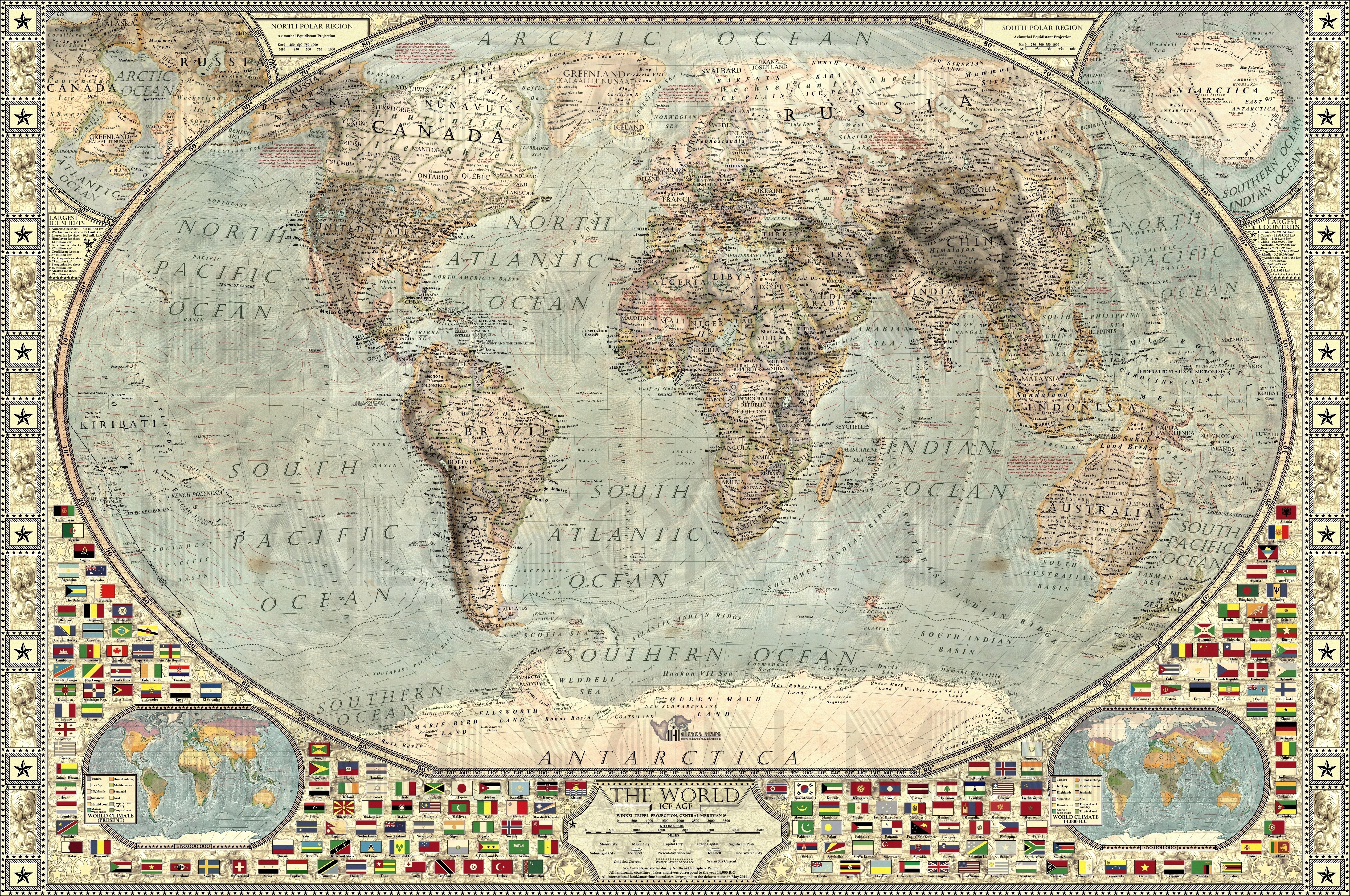
The World - Ice Age, first map of its kind on such a scale and level of complexity, depicts our planet as it looked during the late glacial maximum of the last ice age, 14,000 years BCE.
This world map, inspired by a wide variety of historical maps, aims for bringing the best of traditional cartography to a contemporary setting, while providing a comprehensive scientific-based overview on the subject. While making this map, I cooperated with multiple geologists, to achieve the most trustworthy results and depict the world in 14.000 BCE as accurately as possible.
This map is designed in our vintage-style “decorative” theme, and serves as a perfect decoration for any household, office or school.
The poster includes one full large detailed map of the world, 2 major maps showcasing northern and southern polar regions and 2 detailed minimaps comparing present day climate to that during the late glacial maximum. To better show how the earth really looked 16 thousand years ago when compared to present, map also shows present-day shorelines and modern-day nations and cities(exposing their maritime boundaries).
The world 16,000 years ago was in many ways radically different to the present; because large amounts of water were concentrated in the massive ice sheets covering the majority of North America and western Eurasia, sea levels were about 110 meters lower when compared to today. This exposed massive land bridges, most notably Beringia, Sundaland and Sahul.
Northern hemisphere was covered by two main ice sheets; the Wechselian Ice Sheet, covering the much of northern Europe and western Siberia, reaching as far south as Berlin, and the Laurentine&Cordilleran Ice Sheet complex, which covered almost entire Canada and portions of northern USA. Major ice sheets were also present in mountainous areas, most notably in the Himalayas, Rocky Mountains, Alps and Patagonian Andes.
This World - Ice Age is a comprehensive, factual map of the late pleistocene Earth, and combines the latest knowledge on the subject with artistic cartography to provide you the most encompassing, trustworthy and eye-pleasing overview possible.
You can contact me on my facebook or on 1hourofmusic@gmail.com
I can’t see clearly how much more land around the Azores would have been would have been exposed. Can you comment?