ShopDreamUp AI ArtDreamUp
Deviation Actions


Suggested Deviants


Suggested Collections


You Might Like…


Featured in Groups


Description
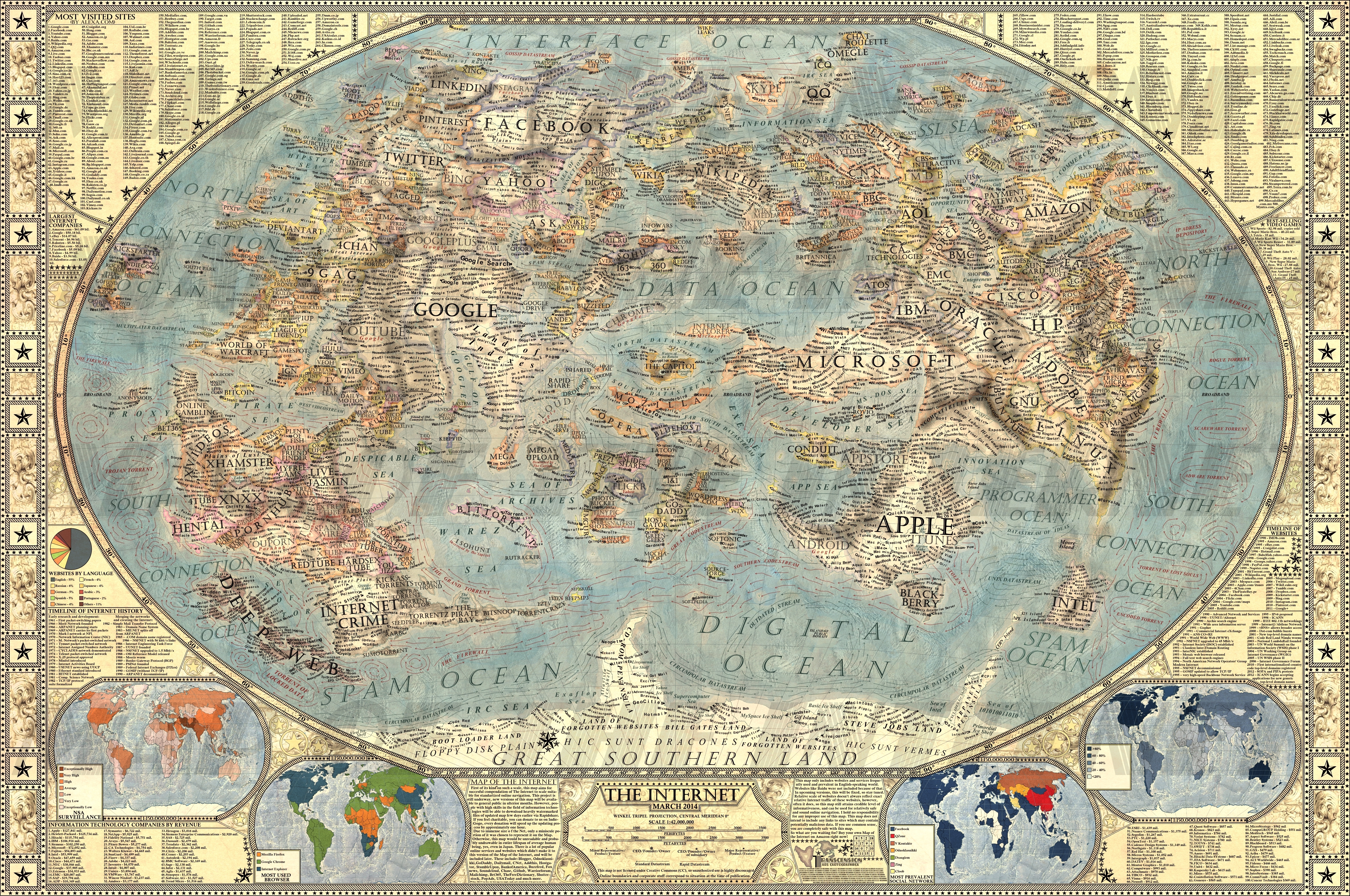
!!!!MAP OF THE INTERNET 2.0 NOW AVAILABLE!!!!
VISIT OUR WEBSITE TO SEE MORE! - www.halcyonmaps.com/
BUY PRINTS ON ZAZZLE! - www.zazzle.com/map_of_the_inte…
CHECK OUT THE WORLD - CLIMATE CHANGE!!! - jaysimons.deviantart.com/art/T…
CHECK OUT VERSION 1.0. - jaysimons.deviantart.com/art/M…
Check out Imperial Decorative World Map on Deviantart - the9988.deviantart.com/art/Pol…
Check out my history blog! - www.historyrundown.com/
Follow me on facebook! - www.facebook.com/halcyonmaps
Second version of our flagship project, the Map of the Internet. This is definitely not the final version, incredible amount of websites and software companies are not on the map and will be incorporated in later updates.
Map of the Internet - First of its kind on such a scale, this map aims for succesful compendation of The Internet to scale suitable for standartized online navigation. This project is still underway, new versions of this map will be available in ulterior months.
Due to the immense size of the Net, only a miniscule portion of it was chosen to represent it on the map. Otherwise, this map would be unreadable and probably undrawable in entire lifespan of average human being.
This poster includes one full map of the internet, 4 minimaps showcasing NSA surveillance, most used social networks, most used internet browser, and worldwide internet penetration, list of Alexa Top 500 websites, quick timeline of the Internet History, top software companies and much more!
By Martin Vargic/Jay Jason Simons
I'm a student and amateur(not full-time professional) graphic designer from Slovakia, Bratislava(Central Europe).
I started making maps about 2 and half years ago, and it has quickly become my free-time hobby. I post my works mainly to deviantart, and until recent days, I was never significantly noticed. It was my hobby, and it still is my hobby, though I am planning to start selling prints of my maps on amazon quite soon(two-three weeks).
Until March 2013, I was working only on minor projects, often making commisioned fantasy map drawings as a side work.
In April, I started to work on my first major project - massive scale political map of the world, which is also on deviantart, and can be found there: the9988.deviantart.com/art/Pol…
In December, I started to work on other two projects, Map of the Internet and Map of the Stereotypes, first version of the Internet Map has already been finished, and Map of Stereotypes will be released sometimes in February.
I was originally inspired by map of the internet created by xkcd, showing most popular social networks as countries and regions, back in 2010. It was not my original idea, but I extended it to such a scale for the first time. I used photoshop for the majority of drawing.
The base style of the map was inspired by the National Geographic Maps, I also used Winkel Tripel Projection and similar border coloring fashion.
The base style of the map was inspired by the National Geographic Maps, I also used Winkel Tripel Projection and similar border coloring fashion.
I created the map in quite a short time, three weeks to be exact. I often worked early in the morning, and I can say I really enjoyed it.
I got the data about website sizes mainly from Alexa and similar online services.
The map is divided into 2 distinctive parts; the eastern continent, "the old world" showcases software companies, gaming companies and some of the more real-life oriented websites
Western part, "the new world" is composed from two major continent, northern one showcasing social networks, search websites, video websites, blogs, forums and art websites.UPDATE: Map of the Internet 3.0. will be released in early May 2014, featuring more than 300 new websites and services!!!
Image size
4827x3206px 18.88 MB
© 2014 - 2024 JaySimons
Comments138
Join the community to add your comment. Already a deviant? Log In
Great work, much appreciated =)